Suriname is the most forested country in the world. According to SBB measurements from 2013, Suriname is still leader in the ranking of countries with the most forest per person, namely 28 hectares for every inhabitant.
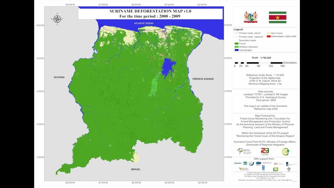
Worldwide Suriname is one of the countries that can call itself a High Forest Cover Low Deforestation (HFLD) country or a country with a high forest cover and low deforestation. Despite this, Suriname has its own challenges to maintain the high forest cover. It is therefore very important to develop a national forest monitoring system, so that, among other things, changes in forest cover can be monitored. Within this system, a number of maps have been produced that provide an overview of the deforestation areas that have arisen since the year 2000. The Foundation for Forest Management and Forest Supervision is the technical partner within the REDD + program, which is responsible for developing the National Forest Monitoring System.
Tools
Tools within the National Forest Monitoring System:
To safeguard our forests and to maintain the balance between the different ecosystems, it is important to set up a National Forest Monitoring System. To make this system effective and efficient, modern technologies are used and there is close cooperation with local communities, government offices and the private sector.
The National Forest Monitoring System (NFMS) consists of six components:
Ad. 1 Satellite Land Monitoring System
With recent satellite images, deforestation maps are produced annually to provide an overview of where most deforestations take place. Post-deforestation Land Use and Land Coverage Maps are produced every two years to reflect the different causes of deforestation. Data on land cover and land use offers the government the opportunity to implement better spatial planning, forest management plans and other policy making.
Ad.2 Near Real Time Monitoring
This is an alarm or alert system, with the aim of detecting unplanned deforestation activities and sending alerts to institutions responsible for enforcing the policy.
Ad.3 Sustainable Forestry Information System
In order to provide even more efficient services and transparency for the timber sector, the Foundation for Forest Management and Forest Supervision (SBB) has switched to the Sustainable Forestry Information System Suriname (SFISS). The work for both the SBB and the private sector can take place more smoothly and in a more structured way. Within this system the sustainability rules are included from the felling of the tree to the processing and export of round timber. For more info also visit: http://sbbsur.com/sfiss/
Ad. 4 Involving communities in forest monitoring
To promote transparency and cooperation with the communities, they are closely involved in the measurement system within the timber sector. To do this, information sessions are organized by means of Krutu's and training community representatives to map out planned logging activities.
Ad. 5 National Forest Inventory
Making an inventory of our forests is important to know, among other things, where the various ecosystems are located and the coherence of biodiversity. In order to measure the changes in the carbon stock in the biomass and to monitor the emission emissions as a result of deforestation, forest inventories are being carried out at various locations in the country. An inventory was recently carried out in the mangrove forests and data is currently available on the occurrence of mangrove in the coastal plain of Suriname. This card can also be viewed on the Gonini website. (Map of places where Mangrove occurs )
Ad. 6 Reporting
Suriname has national and international reporting obligations. For this reason it is therefore important that information is up to date and available. Reports are also important to support development plans. -----------
Since December 2016, SBB has launched a geoportal called Gonini. This is an online database with geographic forest related information about Suriname.
Since December 2016 the SBB launched Gonini, a geoportal with Suriname's forests.


Follow us on social media